As part of my 12-step crash recovery program, I have taken a solemn vow to never again go to a new soaring site without a thorough review of that site's contest waypoint database.
As part of my 12-step crash recovery program, I have taken a solemn vow to never again go to a new soaring site without a thorough review of that site's contest waypoint database.
As many of you know, my Moriarty crash was caused, in part, by an airport that was listed on the database even though it had long been abandoned and was, at best, a place where a landing would certainly have damaged my glider (although nowhere near the extent of the damage caused by my subsequent actual ‘landing’ on a mountainside!). So now I use Google Earth to assess every listed landing site for existence and suitability, and so far I have found that every contest site I have reviewed contained numerous instances where listed airports were no longer there, or were shown at a location miles (literally!) away from the actual, physical landing site. In the recent case of Mifflin, I found that more than 1/3 of the listed landing sites were ‘problematic’ in one way or another, meaning that if you were low and decided to try for an airport, there was at least a one in three chance that you would arrive only to find a suburb or a trailer park instead! (The Mifflin database has since been thoroughly scrubbed and is now in fine shape, thanks to Karl Striedieck, Pepe Sare and Brian Glick, among others).
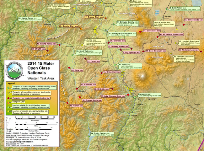
As an unexpected side-result of the review I did for the Minden 18m Nationals (see Minden, Nevada Airport Review and Minden, Nevada Airport Review, Part II), I got an email last March from Jim Darke, glider pilot, cartographer, and proprietor of ‘FlyByNight Services, purveyors of fine contest maps’ (see the above example). Seems Jim was preparing to produce contest maps for both the Minden and Montague contests, and wanted to know if I was interested in collaborating with him to get at least the Montague contest database updated. Coming on the heels of a rather disappointing attempt to engage the Minden ‘locals’, this was refreshing news indeed!
To start the process, I did my normal complete review of the Montague database (which identified about 20 ‘problematic’ waypoints/airstrips) and sent it off to Jim in early April. Jim then took this initial information and, in collaboration with local experts Dale Bush (DLB and the CD for the Montague contest) and Craggy Aero’s Richard Pfiffner (SD), updated the entire contest database. In Jim Darke’s own words from our email correspondence:
“Here is a little more background info that you can use or ignore as you see fit along with anything in my earlier emails. As I said, CD Dale Bush (DLB) and Craggy Aero’s Richard Pfiffner (SD) provided most of the local knowledge. The database review grew out of my affinity for mapping and thinking about some of your comments about other databases. It also grew out of a strong belief that simply creating MORE data does not make things better and is not very helpful. The FAA airport database is a good example of easily accessible voluminous data that is, at best, often misleading. So, how can the maps be any good if the underlying data is bad? Time to clean things up. I pretty much used the same approach that you did. As you know, there is no magic in it, just attention to detail. The devil is truly in the details.
The maps were created using ESRI’s ArcView software (aka ArcInfo, or ArcGIS). It is sort of the industry standard for GIS and mapping, but not particularly user friendly. I fast talked my way into a position as a cartographer when I really needed a job and used it the last ten years or so of my working career.
There weren’t any particular problems in sifting through the data. The FAA stuff is known to be unreliable so finding discrepancies was not surprising. I have found errors there approaching 4 miles – I think that was for someplace in Idaho two or three years ago. I followed pretty much the same procedure that you did. One difference was that I often confirmed findings in ArcView by overlaying the dataset on USGS maps and/or imagery. I’m not sure if that is any better than GE, it is just a more familiar environment for me. Even though the specific data types were quite different, the process was similar to some of the work I did back when I had a job and got paid.
Each time I update one of my maps I try to spend a little time adding geographic names – the white labels found here and there on the maps. I have always found it frustrating at a new site to hear the locals refer to places that are not in the database but are obviously part of the common lexicon. So perhaps if someone talks about finding lift on Cottonwood peak, a new guy can look at the map and see that it is northwest of Craggy Start. Using USGS overlays while composing the map make this task fairly easy although tedious.
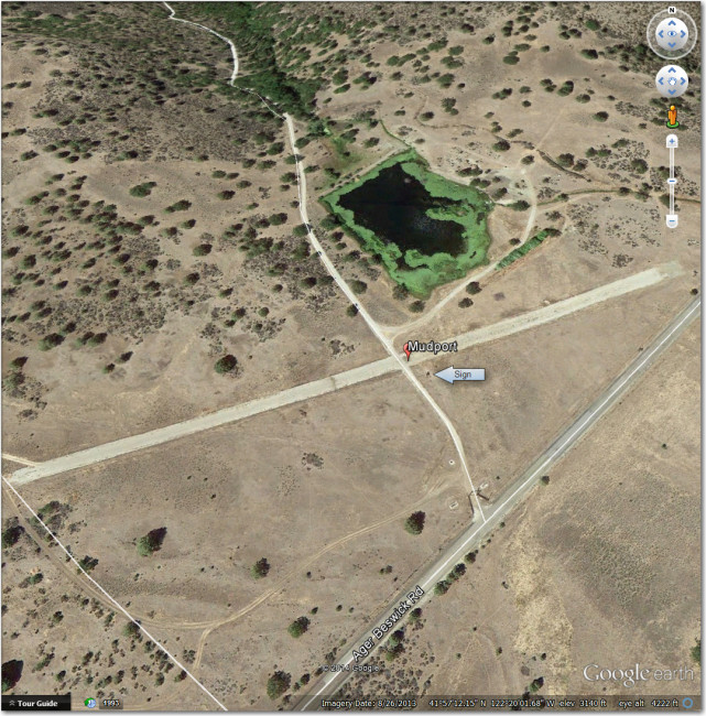
Richard provided data on Mudport. He has landed there. I have been low in that area, knew that there was a strip nearby but couldn’t locate it. It isn’t really tiger country but there aren’t any other good options nearby. Richard also helped with input on the formatting of comments in the CUP files. In some cases, John L.’s parsing routine produced some weird results from my input. I’m not sure if this is a big issue for most folks (does anyone actually read the comments?), but John & I spent a fair amount of time trying to fix things. He is, as you know, great to work with. Richard and Dale both added some locally known thermal hotspots as turnpoints – Craggy South, Pelican Butte, Goose Nest. Richard and Dale also both reviewed my comments on the imagery evaluation.“
For pilots like myself who have never flown the Montague area before and who might not even know they are in real trouble before it is too late to recover, having accurate and up-to-date landout option information can be a literal life-saver. We all owe Jim Darke, Dale Bush, Richard Pfiffner (and another unsung hero – John Leibacher) a huge debt of gratitude for the effort they have expended in updating the Montague database into a much more useful and accurate product. I, for one plan on purchasing (at least) one of Jim’s fine maps for both the Minden and Montague contests!
Frank (TA)
