Background
Contents
When I first starting maintaining the CCSC database, there really wasn’t much in the way of tools to assist a ‘waypoint custodian’ to update the status of existing airstrips and/or include new ones. Here in Ohio (birthplace of aviation, don’t you know!), airstrips pop in and out of existence like, well popcorn. An airstrip that was beautifully maintained last season may be planted in corn this season, and vice versa. You would think that here in flatland Ohio, having airstrips in range isn’t a big deal, as *everything* is landable! However, this is only true for a couple of months at the beginning of the soaring season, say from late March (when our field finally becomes flyable) to the end of June, when the corn crop gets more than about 24″ high. After that, from July through the end of October, airstrips are about the only landing places around; everything else is 6-7′ high corn (this didn’t use to be the case; there were always a few soybean and/or wheat fields around, but the subsidy-fueled ethanol craze wiped out the non-corn crops). I have more than once found myself low over miles and miles of corn fields with absolutely no place to land—a *really* bad feeling! Anyway, the only real information inputs I had back then were pilot reports (“Hey, I think I saw a new airstrip over by Springfield today!”), which sometimes left a lot to be desired, or the occasional pilot who had actually visited an airstrip (voluntarily or otherwise). Later on in the early 2000s I had access to a Cirrus SR22 power plane that I could use to take aerial photos of strips. This allowed me to better assess the current status of airstrips, but it was hugely time-consuming and prohibitively expensive.
About five years or so ago I discovered Google Earth (GE), and this has totally changed the way I do soaring site assessments. Now I can not only look at my home club’s soaring area, but also anywhere else on the planet—it’s wonderful! For instance, a few years ago, I was able to significantly expand our soaring area by doing an in-depth GE review of the area and (re-)discovering a number of airstrips that made it practical to go there on cross-country flights, with some assurance that good landing sites were available even when the crops were high. Also, about this same time I discovered that John Leibacher’s wonderful Worldwide Soaring Turnpoint Exchange (WSTX) offered, as part of it’s normal smorgasbord of waypoint file formats, a ‘KMZ’ format directly compatible with GE. This meant I could view all CCSC waypoints in GE and see how they lined up with the actual geographic ‘ground-truth’ (and boy, was I shocked at the number of mistakes I found!). The other thing I discovered in all of this is how easy John was to work with and how responsive he was (and is) to even us Joe Schmos at Podunk Soaring Club. I would send an email requesting an update, and the updated files would appear almost before I hit the send button—almost as fast as ordering things from McMaster-Carr ;-). Not only did John respond quickly, but he quite often improved the quality of the product, kindly pointing out the multiple ways in which I had screwed the pooch and suggesting better ways of proceeding, or in the case of this last update, pointing out an airstrip that I had missed.
The rest of this article is about my latest adventure in updating the CCSC database, and it is also about John Leibacher and the Worldwide Soaring Turnpoint Exchange. We in the soaring community (and me in particular) owe John and the WSTX a huge debt of gratitude; I don’t see anyone else acknowledging that, so this is my way of saying “THANK YOU!!!” to John.
Updating the CCSC waypoint database
Updating a soaring site’s database involves a number of semi-discreet steps:
- review the existing waypoint database in Google Earth (GE)
- add/remove/edit waypoints as necessary
- work with John Leibacher to get the new waypoint database uploaded to the WSTX.
Review the Existing Waypoint Database
First, I retrieve the .KMZ file from the current database (note: this is not always in the list of files available in the ‘Files formatted for downloading and importing into your programs’ section, but it *is* available in the ‘all of the above’ ZIP file associated with most soaring sites (John refers to this as the ‘Charlie Spratt’ file, apparently because Charlie was the one that first asked for everything all in one file). Once I have the KMZ file I simply drop it on Google Earth (GE) and GE opens it (it actually first unzips it into a KML file) with all the waypoints overlaid on the appropriate geographical area. The KMZ waypoints are shown in GE’s sidebar in the ‘temporary places’ section, as shown in the following screenshot.
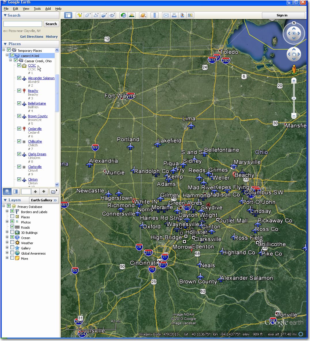
Google Earth with CCSC KML (unzipped version of KMZ) shown
with the KML file loaded, clicking on the little ‘+’ sign expands the contents to show individual waypoints, and each item in the list is itself a link to that particular spot on the map. Double-clicking on any waypoint link causes GE to pan/zoom appropriately to center the desired waypoint. This makes it super easy and convenient to systematically review each waypoint simply double-click on each one in turn to center it—no thinking required! Individual waypoints (like grass strips which have highly variable widths/lengths) can be accurately measured using GE’s ‘ruler’ tool, as shown in the following image (now that I have my new 18m wonder-glider, I worry a lot more about an airstrip’s width than its length). When reviewing a particular waypoint in GE, it is important to look at the image date, located at the bottom of each image (for instance, in the image below the date is 10/10/2013). In my work with many different soaring sites, I have found that GE actually updates their aerial imagery quite frequently, with most images less than two years old.
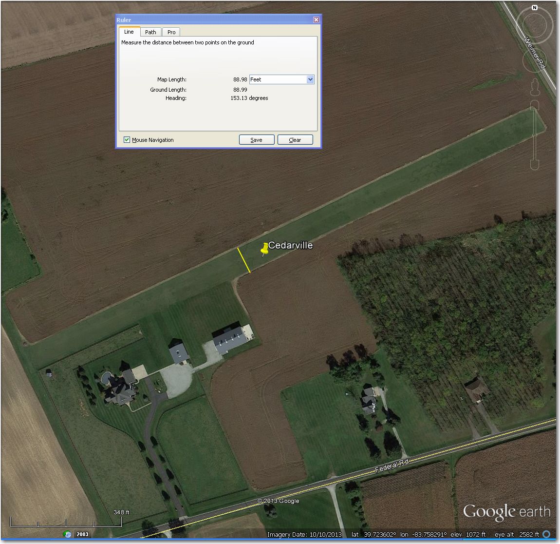
Using GE’s ‘ruler’ tool to measure the width of a private airstrip near Cedarville, OH
Add/remove/edit waypoints as necessary
Once I have reviewed all the existing waypoints (non airstrip and otherwise) for accuracy and ‘current status’ (GE’s version of ‘current’ may be as much as two years, or as little as two months out of date), the next step is to add/remove/edit waypoints as necessary. In the case of this particular update to the CCSC waypoint data, we made the following changes:
- Removed some existing ‘landing point’ waypoints that we knew to be abandoned and/or un-maintained
- Added a number of ‘close-in’ turnpoints (not necessarily landing points) for the upcoming 2014 1-26 Championships.
- Added a number of newly-identified airstrips
- Added waypoints to ‘fill-in’ blanks in the soaring area.
For the first item above, I had some personal first-person knowledge of problematic airstrips from my own flights at CCSC, some second-hand information from other pilots, and of course, information from GE itself. For each ‘problematic’ airstrip, I correlated a very thorough GE review with first or second-hand information to make a decision. In the case of CCSC’s soaring area, we decided to remove four contest turnpoint airstrips (#10 Double J, #13 Fricke, #14 Frith, #26 Merritt) and an additional two non-contest turnpoint airstrips (Hanshell Flying Apple, Mite). The GE images in all cases were recent enough to be definitive, even in the absence of ‘local knowledge’.
For the second item (adding close-in turnpoints), GE was used exclusively to identify and locate ground references that were at about the same distance from CCSC and were evenly spaced around the compass. Once the points were identified, then the coordinates were read directly off the GE image. This ability to match a visible object on the ground with a precise latitude/longitude coordinate pair is an extremely powerful aspect of Google Earth. The image below shows the original layout of the proposed ‘close-in’ turnpoints. Note that the red lines from each turnpoint are produced in GE via the use of the ‘save’ feature on the ‘ruler’ tool.
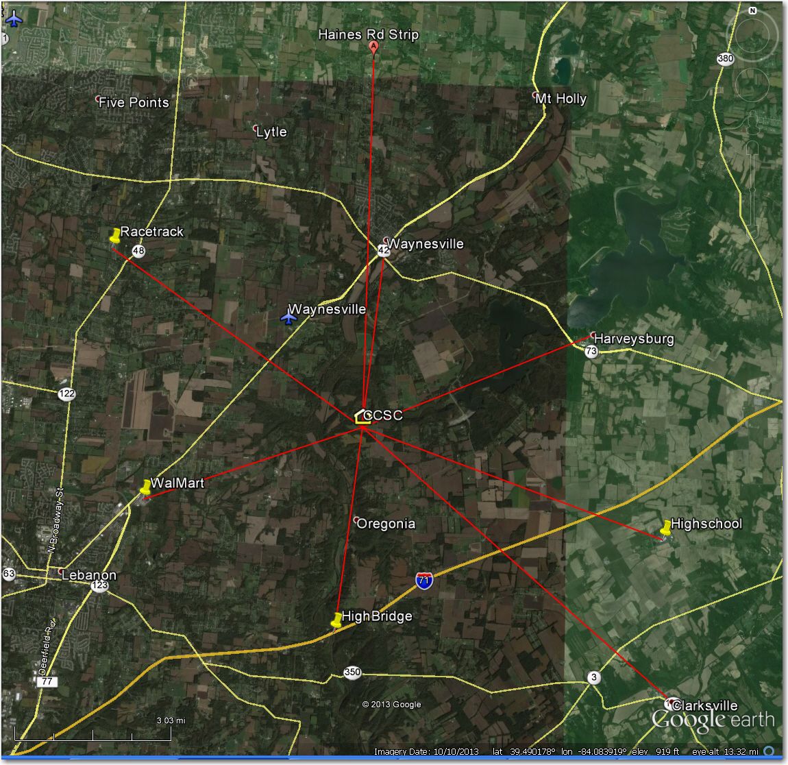
Close-in turnpoint selection for CCSC
Work with John Leibacher to get the new waypoint database uploaded to the WSTX
Once all the desired changes have been made to the waypoint configuration for a site, and ‘signed off’ by a site’s interested parties (in the case of CCSC, the contest manager and another experienced XC pilot), then the challenge is to provide the updated database to John Leibacher in a format that can be used to produce the gazillion or so other formats used by soaring nav systems from GlideNav II all the way to LX9000 and XCSoar.
In my experience, John will work with just about any format, but some are inherently better than others. For instance, John’s own ‘Soaring Turnpoint Exchange’ (STX) format typically contains more detailed information about a waypoint (such as runway length, width, surface and heading) that can be exploited by some nav systems (like ClearNav) to display more information on their moving maps. STX files can be a bit intimidating to work with as their default tab-delimited layout doesn’t line up very well in a typical text reader application like TextPad or Notepad. Excel does a nice job importing and displaying tab-delimited text files, but unfortunately also can be a little too smart for its own good by interpreting “18/36” as “0.5” – yikes!! ;-).
For this exercise, I chose to import the existing tab-delimited STX file into Excel and make the desired modifications there—and finally beating Excel into submission on the “18/36” issue by forcing all the fields to ‘Text’ vs ‘General’. Once all the changes had been made, I saved the file as a text-formatted file with a STX extension, and sent it off to John for review and processing.
Getting a modified file up on the WSTX for public consumption typically involves a fair bit of back-and-forth with John. When John gets a file, he doesn’t just stick it into one end of a sausage-grinder and turn the crank; he actually looks at the contents and applies some common-sense verification techniques. For instance, I had three grass airstrips coded as “AT” (Airport/Turnpoint), but when John ran the locations against the FAA airport database for the region, he came up blank. This means these airstrips aren’t known to the FAA, and therefore shouldn’t be called ‘airports’. The compromise we came up with was to recode them as “LT” (Landing place/Turnpoint) and party on. Most soaring nav systems are smart enough to depict “LT” waypoints either with an airport symbol or as (in the case of ClearNav) a distinct ‘landable point’ symbol. In another case, I had a non-landable waypoint coded as “T”, but it came back from John coded as “AT” because his automatic airport-to-location’ matching algorithm found an FAA-registered airport 1.3 miles away. In this particular case, I knew the actual turnpoint wasn’t landable, but also was flabbergasted to find there actually was an airport visible in GE, right where John said it was! (I have been flying over that airport for the last 15 years and never saw it). In all of this, I have always been pleasantly amazed at how responsive John is; we will sometimes go through several email-based iterations on the database in the same day. When the result becomes nearly final, John will start running it through his format distribution engine to produce all the various file formats, so that the results can be end-to-end verified. In my case, I always grab the newly-produced KMZ file and drop it into Google Earth to make sure the waypoints actually line up with the underlying geographical elements (an airstrip, high school, or WalMart, etc.). It’s not unusual in this stage to find that rounding errors or typos have moved a waypoint symbol away from the actual geographical element, so it is very important to do this until all waypoints have been verified to be exactly where they are supposed to be.
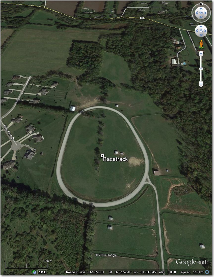
Racetrack ‘Close-in’ Waypoint
So, that’s it—The new, improved CCSC database is up on the WSTX and available for download as I type this. Of course, there may still be errors and/or problems, but I have really tried hard to minimize them. If you see anything wrong, please contact me immediately so I can work with John to fix them.
Frank (TA)


4 comments for “Updating the Caesar Creek Soaring Club Waypoint Database”