- Bloemfontein South Africa Report, Flying Day 13 (last) – December 4
- Flying Day 12, December 3
- Flying Day 11, December 2
- Flying Day 10, December 1
- Flying Day 9, November 30
- Flying Day 8, November 29
- Flying Day 7, November 28
- Flying Day 6, November 27
- Flying Day 5, November 26
- Flying Day 4, My Birthday
- Flying Day 3, Thursday 11/24 (Thanksgiving)
- Flying Day 2, Wednesday 11/23
- Flying Day 1, Tuesday 11/22
- Introduction
It will help to understand today’s flight if you scroll down to the Introduction section below and look at the map of the 3 controlled airspaces. Essentially, 3 of us (myself, Ed Downham and Anders Anderson) flew a task clockwise around the Bloemfontein TMA and down the narrow corridor between that and the TMA to the east (which is for Maseru – capital of the kingdom of Lesotho). It was a fascinating flight over terrain that I have never seen before (only one of the 3 of us who did it had done it before) and it was especially difficult for me because I did not have any moving map display in my glider and mostly had to rely on a “real” map. On the far east side I flew over a large town called Thaba Nchu with a beautiful mountain near it. Most maddening was flying in the southern extension of the TMA where we were prohibited from flying above 10,500 msl. The terrain was completely unlandable in all directions as far as I could see – yet I had to leave 9 kt thermals at 10.5 K (6000’agl) because of airspace restrictions – which make no sense considering the limited traffic in and out of Bloemfontein. Still – it was one of my most memorable flights and a flight that has been done here only once before (by Anders Anderson who flew it with us today). 498km in 5.8 hours.
![SeeYou - [1C2GBOU1.IGC] 12102011 90722 AM](https://soaringcafe.com/wp-content/uploads/images/2012/06/SeeYou-1C2GBOU1.IGC-12102011-90722-AM-600x364.jpg)
See You map of the flight. The light green areas are the places that allowed flight below 10.5 k (6000’above ground).
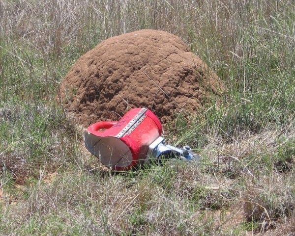
Cross country flying here is a little different than back in New England because airports are very sparse. The nearest airport to Bloemfontien is at Bultfontein – 85 km away. It is essential to land in cultivated fields (and preferably near to a paved road). While some uncultivated fields may look landable from the air, all are loaded with thousands of meerkat holes or the ubiquitous anthills that have the consistency of cement. Either will wreck a glider. Below is a fairly small anthill – with the Nimbus tail dolly for perspective:
