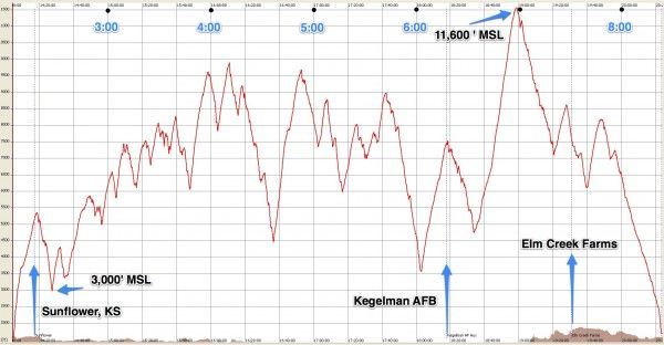
Well I had a great soaring flight yesterday. I decided to fly the NG-1 since my Cherokee is in the garage right now and I’d like to do some work on it over the next few weeks. Plus the weather was looking good but not booming and if I flew the Cherokee I would want to do a 300 km declared task. So Leah and I rigged the NG-1 and I declared a 300 km triangle in it. route was Sunflower (SN76) to Kegelman AF Aux (KCKA) to Elm Creek Farms (99KS) and back to Sunflower. I had hoped for a noon launch but as usual everything took a little longer. I took off at 1 PM and was the first of the XC guys to launch.
The beginning of the flight was still a bit of a struggle to get as high as I wanted, even with the late launch. I slowly crept south, taking every decent thermal I found, and each one got me 500-1000 feet higher than the last, which was comforting. Conditions were “blue” today with no cumulus clouds so I was depending mostly on dumb luck to find the next thermal. The extra L/D of the NG-1 helped in extending my range and ensuring I found the next thermal. One time, near Anthony, I actually turned towards the airport where I saw a good dust devil. But when I got half way to it I hit a 500 fpm thermal so I took that one. Up until that point I had been unsure about actually completing the task, considering how I had started to get lower and lower and the lift seemed to be a little weaker. I didn’t want to land out as Leah was working the line yesterday and wasn’t going to be too happy if she had to come get me.
But then I started to feel that I had Kegelman made and if I could find some more lift could at least start getting closer to home as I worked my way back. Kegelman is bordered on the west by a lake/salt flat and has a pretty good area of trees and other non-landable terrain to the north for about 15 miles. So I needed to get some altitude before I headed across that. As I result I got sort of “stuck” about 25 miles out until I was able to climb back up to where I needed to be. It was a long glide over the trees to Kegelman. Then what? I didn’t want to go around the north side (downwind) of that lake so I started to run west along the south side of it, towards Cherokee, OK. Out of the way, yes, but I couldn’t afford much more of that long smooth glide business. I found a good thermal a bit west of Kegelman and got back up to around 9,000 feet. With that I headed out over the “lake effect” area which wasn’t as dead as I had feared. Once on the other side, probably about 20 miles down the second leg, I got low again but found a nice steady thermal that took me to my high altitude for the day, 11,400 feet! From here I could see my second turnpoint and knew I had it made and could make it a fair distance home.
I didn’t really realize how late it was but I topped out of that thermal at 6 PM. Blissfully ignorant of the setting sun I glided towards Elm Creek and caught a little thermal just before the turnpoint, which boosted me back up to 8,500 feet. I rounded the west side of the “airport” which looked like it hadn’t been mowed in ages, and that was from 6,000 AGL. Now it was a straight downwind run back home. I was about a mile above landing altitude and 47 nautical miles from home. I did notice that the shadows were starting to get pretty long…the air was dead smooth. All I could do was fly as conservatively as possible. I held the speed between 60 and 70 mph for most of the last leg, depending on whether I found some zero sink or if the sink increased. For the most part everything was very steady. I did find one small thermal, maybe 100 fpm, that I milked a couple hundred feet from. But by the time I crossed US 54 west of Kingman I was on final glide. I just didn’t what I was on final glide to!
I could see where I thought Sunflower should be, but the angle was really flat. However, it didn’t appear to be moving up in the canopy, so I suppose that was a good thing. The air was completely dead. I knew I had extracted everything I could out of the day. There were plenty of dirt fields in the last 5 or 10 miles leading up to the airport so I figured I’d get it down safely regardless. So, I just kept coasting…and the airport appeared to start moving down in the canopy, ever so slightly! I was cautiously optimistic. I knew I needed to get a good finish by flying to the northeast of the field but that would be where I wanted to be for a traffic pattern anyway. But would I have enough altitude for a pattern? This was by far the diciest glide I had ever made. My flight computer battery had died long ago so I was judging it totally by eyeball. I wondered how good my judgement was after 6 hours cramped in the cockpit, sweating like crazy. The high temperature for the day was ~100 on the ground. I had been drinking water at every opportunity but stupidly forgot to bring food. I knew I was dehydrated to a certain degree, and that my blood sugar was low. Now was not the time to try something stupid.
Once I was about 10 miles out, I was pretty certain I would make it. At five miles I knew I would make it. I crossed the south end of the runway at 1,000 AGL, entered downwind and landed. Leah, Rafael, and Jerry were out there to watch. Jerry had landed just 10 minutes earlier. All four of us were happy that I had finished the flight and amazed that I had made it back. I still can’t believe it.
The flight should be good for my Diamond Goal flight as well as at least four state records.
Sorry, no pictures, but I did upload the flight to the OLC last night. It was good for second in the US, 16th in the world. Missed 1st place in the U.S. by only eight points.
http://www.onlinecontest.org/olc-2.0/gliding/flightinfo.html?dsId=1874513



4 comments for “Diamond Goal”