Minden, NV to Hullett Airfield, WY: ~1401 km (~870 mile)
Minden, NV to Hullett Airfield, WY: ~1401 km (~870 mile)
Although Gordon and Hugh didn’t make their declared goal at Rapid City, South Dakota, they did land safely at Hullett, Wyoming, which is approximately 870 statute miles (1401 km) from their takeoff site at Minden, Nevada. That’s about 170 miles longer than the existing U.S. Free Distance/Multiplace record, which they set on April 15, 2013. Congratulations to the Dynamic Duo for another record-setting flight!
Thanks to Walt Rogers for providing weather forecasts and reports, and frequent status updates during their flight.
Here are some post-landing photos…
900 PDT – Update from Walt Rogers
Gordon and Hugh landed at Hullett, WY approx 1849 PDT 1945 MDT. Approximately 870 statue miles or 1401km from Minden. Here’s a photo of the airport


Satellite photo before sunset:

————————————-
Walt Rogers will be blogging and tweeting updates throughout the day as Gordo and Hugh make their way from Minden to their goal at Rapid City, South Dakota. We will retweet Walt’s tweets. Our twitter handle is @SoaringCafe and Walt’s is @wrogerswx .
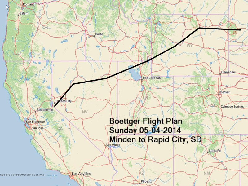
Click here for more information about the flight plan and for links to their flight track on DeLorme’s tracking site and FlightAware
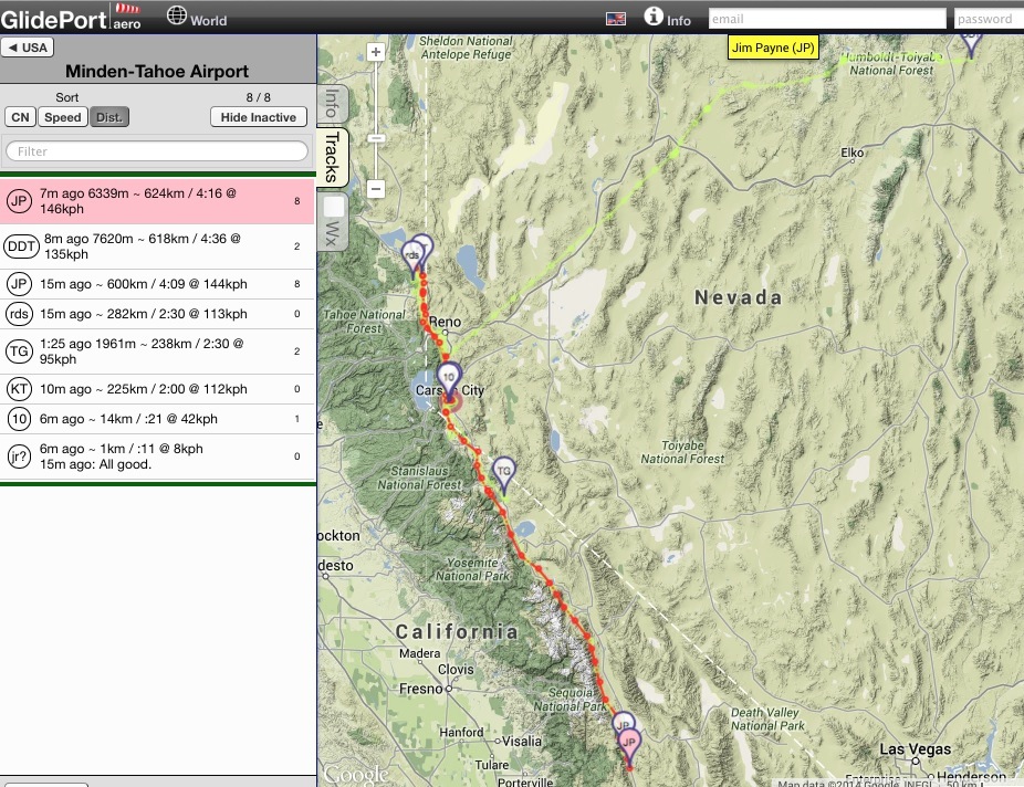
1020 PDT Update – GlidePort.aero
Gordo and Hugh – light green track to NE
Jim Payne and Dennis Tito (DG-1001M) – N-S red track
2310 PDT Sat 05-03-2014 Update from Walt Rogers’ Blog…
The flight plan looks very similar to previous downwind attempts:
Here’s a look at the weather pattern for mid day, 1300 PDT Sunday, during the proposed flight.
The 300mb Winds (top left) show the FL300 jet stream axis from SW Oregon into North Dakota. The proposed flight path is on the southern edge of the jet, which is optimum for a downwind wave flight. I say optimum, because flight is far enough away from moisture and precipitation and is in a region of sufficient wind velocity. Wind speeds are 70 to 85 knots at FL300 which is just above Gordon’s IFR clearance for top of climb in wave at FL280. The 500mb flow at FL180 is sufficiently strong W to SW at 50 to 65kts. Notice the 700mb moisture greater than 70 per cent (light green) well to the north. One complication with the flight to Rapid City is that he must fly across a shallow stationary frontal zone near the eastern border of Wyoming just before crossing the Black Hills. That cool layer may contain a stratocumulus deck just east of the Black Hills at the end of the day from 6500-8500msl. Plans are for Gordon and Hugh to make one last final climb to FL280 off the south end of the Big Horn mountains. Then continue with a 186 statue mile downwind glide!
Overall, the weather pattern looks to be excellent for a successful flight. The biggest questions is how long it will take to reach Top of Climb (TOC) near Carson City at FL280, and regain altude downwind over ranges in North Central Nevada. If everything goes well… that is fast locating of wave climb when it’s needed, Gordon should arrive in the Logan Utah area around 1pm. As a meteorologist, I’m most pleased to see that extensive cloud cover should not be a problem. There will be times when glide descents will be in thin layers from 16,000 to 24,000 msl.
Sunset at Rapid City, SD is 1900 PDT … end of civil twilight 1932 PDT. If Gordon launches at 0530 PDT 14 hours of flight time.
Click on images for full size


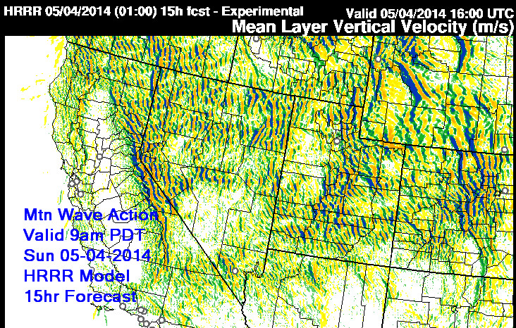
The last look at how the mountain wave pattern looks Saturday night can be taken from the HRRR model Mean Layer Vertical Velocity valid 16Z or 0900 PDT Sunday:
0645 PDT Sunday 05-04-2014
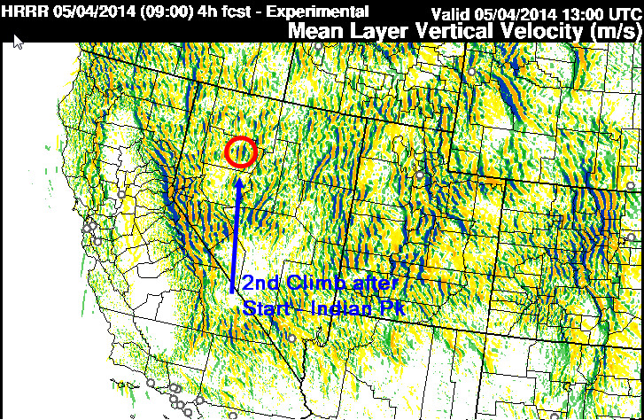
Gordon and Hugh launched their Duo Discus N55LK at approximately 0534 PDT. By 0553 Gordo called to report “Going up like gangbusters!” climbing through 17,000msl. They reached 26524 msl by 0607 PDT and after cruising around near FL280 turned downwind at 0635 PDT near Washoe City. Ground speed 169mph now headed toward Indian Peak approx 98 status miles away.
First visible GOES Satellite Photo
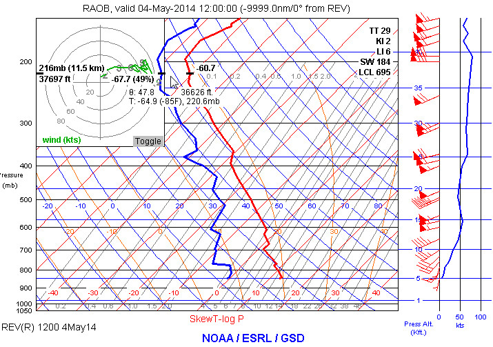
Here’s a Radiosonde observation at Reno 1200Z 0500 PDT
First climb ended up occurring just 5 nm NE of Sonoma Peak… 8nm SSE of Winnemuca at 2 kts. After topping out there, they headed for a lennie near Adam Peak and reported at 0809 PDT going up at 4 kts1505 PDT
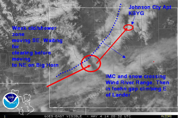
Crossing of the Wind River Range after climbing to FL280 near Bear Lake was a bit harrowing. Just as Gordo crossed at 1343 PDT, He encountered IMC, snow in cockpit and tremendous sink on lee side. Finally broke out in clear at 1356 PDT just east of Lander, WY.
What happened was a weak “baroclinic zone” or vestial front brought increased cloud cover and radar 20dbz reflectivity, light snow showers, to the Wind River and Big Horn range. This cloud mass is moving steady eastward and expected to clear out of the next route segment within the hour. In the meantime, Gordo is climbing slowly in disorganized wave 4-9nm ESE of Lander, WY.


1 comment for “Gordo and Hugh Set New U.S. Multiplace Free Distance Record”