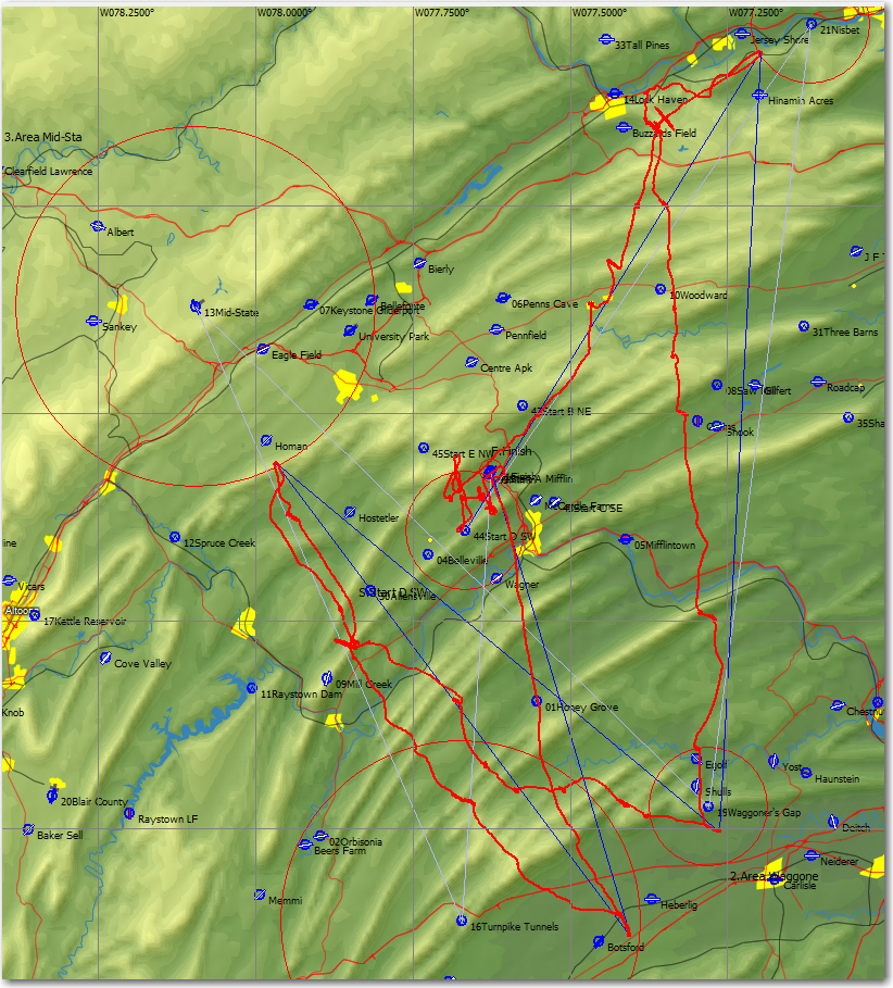
8kt climbs, 8kt sink, streets, overcast, spreadout, rain and snow – OH MY!
Today was a classic Mifflin non-ridge day. A very unstable air mass with a significant cap kept us from getting T-storms, but we had just about everything else – wave, wave suppression, 8-10kt thermals, streets (some even aligned with the wind), blue holes, high overcast, spreadout, rain showers, snow showers, and just about anything else that can possibly happen short of thunder and lightning!
Weatherman Richard Kellerman (QV) nailed the weather pretty accurately at this morning’s pilot meeting (where he also gave the talk as the Day 1 18m class winner!), and gave us enough clues so that most pilots weren’t interested in hanging around for very long after the gate opened. Of course, the CD calling *another* 4-hour minimum task for all classes might have had something to do with that as well ;-). Here’s a quiz for you; where in the soaring world do you have a SRO regional contest where every class (4 this year with the addition of Open Class, aka Dick Butler Class) is a Nationals in all but name, and a regional where National-length tasks are routine? Answer – only in the USA (Perry and Mifflin, respectively) ;-).
Anyway, I digress. CD Pepe Sare wasn’t here today, so scorer John Godfrey took the reins and declared a 11:00 grid time in an effort to get everyone on course (and hopefully home again) before the day completely crapped out (he was mostly successful, but not quite). The bad news for me was that 18 meter class was in the back of the bus today, which meant we would be the last ones out on course. The good news (for me) was that I was the first 18m glider launched, so at least I had some extra time to climb before the gate opened. As it turned out, climbing to start height (6000′ today) wasn’t the issue – getting back down to 6000′ was the problem! With about 3 minutes to go before the start gate opened, I was at about 8000′ after a ho-hum 7kt average climb, and so had to spoiler down to about 5000′ to run out my 2 minute below-altitude time before starting out the top. When the gate opened I was racked up in a climb with John Seymour (SM) and we both blew through 6000 without even a ‘how do you do’ ;-).
Out on course, we could see that the weather in the direction of the first turn area (21 Nisbet – 5 mile radius) was already OD’ing, and we were still 50 miles away! SM figured out how to take a street that was about 20-30 degrees off course, and then hung a right for about 10 miles to nick the turn, and then retreated the 10 miles again to get back to the good stuff. Fortunately we were getting to 8000′ by the time we got near Nisbet, so it was possible to do the 20 mile round-trip and still have enough altitude to connect at the end. This was the first time I’ve ever had to deal with this kind of wild variation in soaring conditions, so it was a real eye-opener (and sphincter-clincher at times) for me. After getting in and out of Nisbet successfully, the run down to #19 Waggoner’s Gap (5 mile radius) was more or less routine, assuming you count mind-boggling climbs, sustained sink of over 8kts, and street flying under a 75% overcast as routine! The weather changed yet again on the way to #13 Mid-state (15 mile radius); the good news was we got out from underneath most of the overcast. The bad news was, we also got out from underneath most of the clouds! And, when we did have clouds, about half had rain and/or snow showers under them – yikes! As we (I was flying with Brian Milner (GJ) for part of this leg) approached the Mid-State circle, we again had to deal with lower cloud bases and spreadout/OD. Again, the correct technique was to sneak up on the edge of the circle as high as possible, run in and nick the edge, and then get the heck out of Dodge before the weather gods notice. All this nicking of circles meant that the only way to get to min time was to go all the way to the back of the last circle (#16 Turnpike Tunnels), and that meant a looonnngggggg upwind final glide over the Tuscarora, Shade, and Jacks Mountain ridges to get home. I topped out my last climb at better than 9000′, 45 miles from home and about 2500′ over final glide at MC 3.0, and I was still worried. The direct line to home from where I was meant that I had to go right over the top of Jacks Mountain at about 2200′ followed by a dive to the finish line at 1400′ less than 2 miles away. This meant that I was really final-gliding to the top of Jacks Mountain, not the finish, and my minimum altitude was 2300′ at 3 miles, not 1400′ at 1 mile. I could have tried for the Union Gap and run Jacks Mountain home, but what if the ridge wasn’t working? – oops! I could also have gone through the Rt 322 gap, and I seriously considered that for while during the glide. The problem with that route is that if it didn’t work, I’d wind up low in the gap with nowhere to land – oops again! In any case, what I did was fly the glide very conservatively, and only sped up (to almost VNE) after clearing the top of the ridge.
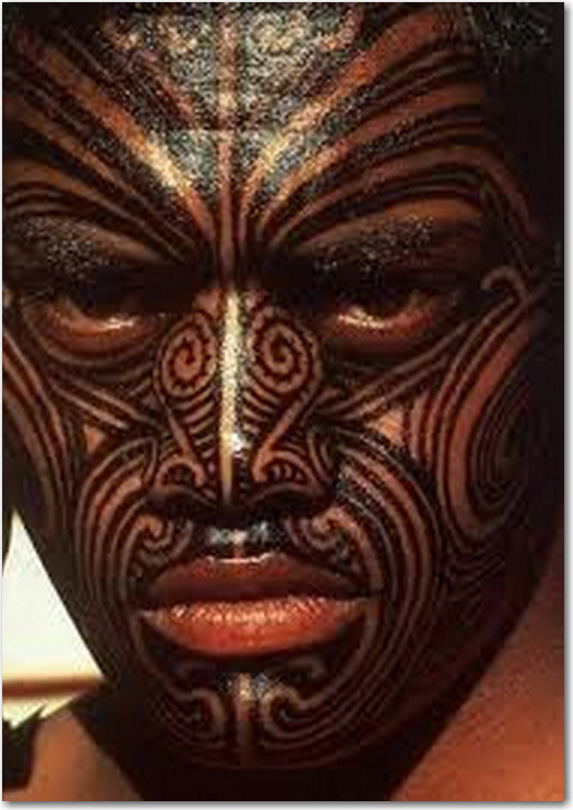
Flying at 8000-9000′ gives a different perspective to the Mifflin soaring area. You can see all the ridge systems of course, but you can also see how the valleys are laid out – some with small towns, but most with just scattered houses and lots of farm fields. Apparently a common farming technique here in Amish country is to alternate crops in long narrow fields, with a brown plowed strip right next to a bright green one (no idea what the crop is). From over a mile up, you can see hundreds of these alternating strips all the way up and down the valleys, and your (or at least my) mind tries to make some sense of the whole picture, as if there is a pattern in there somewhere if you just look hard enough. In one valley, there was more rolling terrain than usual, so the alternating green and brown strips weren’t lined up neatly, but were rather scrolled around and over hills. For a moment there I got the impression that I was looking at a small part of the tattooed face of a Maori tribesman, which I guess made me something about the size of a gnat! ;-).
Another interesting thing – many of the streets today were not lined up with the wind line at altitude. They were definitely streets, but on the first leg we were flying streets oriented almost 90 degrees to the wind line. I first saw this happen at Perry many years ago, and refused to fly that street as it was not ‘properly aligned’ and therefore could not work (you can guess how that turned out for me). Since then I’ve relaxed my criteria for street flying considerably. Now, if it looks like a street, acts like a street, and my glider goes up more than it goes down – then it’s a street! ;-). The winds today were quite strong (around 15-20kt) at altitude, generally out of 290-300 deg. However, as you can see from my trace, the first leg of the flight runs northeast, almost at right angles to the wind line. Then the second leg was almost due south, and it too was a streeting leg. The third and fourth legs were reasonably well aligned with the wind line, but they didn’t feature a lot of street flying – go figure!
OK, I’m going to knock it off for the night for fear of overtaxing my recently reincarnated Muse. Tomorrow looks a bit iffy, both from the popular weather forecast and from XCSkies. XCSkies in particular is calling for 100% overcast shortly after 2pm local time – but who knows – this is Mifflin, and anything can happen here! Stay tuned
Frank (TA)


