Contents
Introduction
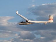
On Saturday June 1, 2013 I crashed my Ventus 2bx glider into trees on a mountainside near Moriarty, NM. Miraculously I walked away (literally, as I had to hike more than a mile to the nearest road) with only very minor scratches and a bruise or two, but the plane was very heavily damaged. It was the 2nd practice day for the 2013 Region 9 soaring contest at Moriarty, and it was my first time flying in this area.
This article is intended to describe, in as much detail and in as objective a manner as possible, the factors and decisions that led to a wrecked glider on a mountainside and the subsequent successful rescue effort. Almost all aviation accidents occur at the tail end of a long ‘accident chain’ of events and decisions. Quite often it becomes clear in hindsight that a slightly different/better decision by the pilot at an earlier time or position would have broken the accident chain and prevented the accident. In the case of fatal accidents we wonder why the pilot made such an obvious series of blunders, but of course the pilot is no longer around to tell us why. This particular accident certainly had the potential to be fatal, and in fact I’m still not certain why I survived at all, much less walked away almost completely unscathed.
I have tried to give this account in as objective and dispassionate a manner as possible, but of course there is no way to really do that. I am certain that readers will find fault with much that I have described, and will find plenty of ways to say “boy, were you an idiot – I would never do anything like that!” I am reminded of a quote by another soaring pilot that goes something like this: “I told myself I would never do anything like that – until I did”. I wrote this account for two reasons; first, I didn’t really understand what happened myself, and I didn’t think I could get past the mental trauma without examining what happened in detail. Secondly, I felt I owed the soaring community an account of what happened, even though I’m pretty sure it will result in some (or a lot of) negative feedback.
Some Background
In 2011, Mark Hawkins (who happens to live now in Moriarty) and I gave a talk at the SSA convention entitled “GPS-based Sailplane Tracking”. This talk described the then nascent SPOT satellite tracker and the beginnings of the SSA Sailplane Tracking List. Part of the talk featured a description of the search and rescue effort associated with an August 2009 fatal sailplane accident in Idaho. The pilot in this case was not carrying a tracker, and the crash site was not found until over 24 hours after he had failed to return even though the crash site was only about 25 miles from the gliderport. As a result of this crash, Mark and I created the Hawke Tracking SPOT tracking application for contest and club use, and also worked with others in the glider community to develop and promote the SSA Sailplane Tracker List on the SSA website. Little did I know that just over two years later, I was going to be the beneficiary of that same SPOT tracking technology.
I fly cross-country a lot, and I land out more than I really like to admit. Consequently, my landout kit is probably a little more robust than some. I always fly in jeans, long-sleeved shirts, and good New Balance running shoes. In the last year or so I have also started wearing gloves (due to an unfortunate encounter with antibiotic-induced sunburn at the 2012 Seniors). My landout kit includes a tow rope with a metal hitch ring, a book for those long landout waits, a carrybag with a long shoulder strap, my heavy-duty fabric canopy cover, and a small 2’ x 3’ waterproof rug for under-wing taping. In addition, I carry a lunch bag with extra food and a second cellphone – a simple pre-paid Verizon flip-phone (I have found over the years that my primary Sprint PCS cellphone has poor or non-existent coverage in many soaring areas, but Verizon coverage seems to be much better in remote areas).
In addition to my landout kit, I also of course carry water in a large CamelBak, and I normally carry at least one 20 oz Gatorade bottle with me as well. And, of course I have my SPOT securely stay-strapped to my parachute harness and within easy reach within the cockpit. I also have a 121.5 MHz ELT, but I don’t really count on it for much as the 121.5 MHz satellite system has been decommissioned and typical VHF direction finding is not particularly fast or accurate.
Weather
The weather for the day was (I am told) a bit unusual for Moriarty in that it was not supposed to be windy at all. Basically light and variable the entire day, with thermal tops between 10,000′ and 14,000’ msl (4,000’ to 8,000’ agl). Very few, if any clouds would be present. So a relatively weak blue day, but light winds so the buoyancy / shear ratio would be reasonable.
Terrain
The terrain in the Moriarty soaring area is challenging to say the least. Although not particularly mountainous, my impression is that there aren’t that many areas where a safe landout can be accomplished – it is basically an airport-to-airport operation. The good news is that there are a fair number of airports and gravel strips, so keeping an airport in range isn’t an impossible task.
Task
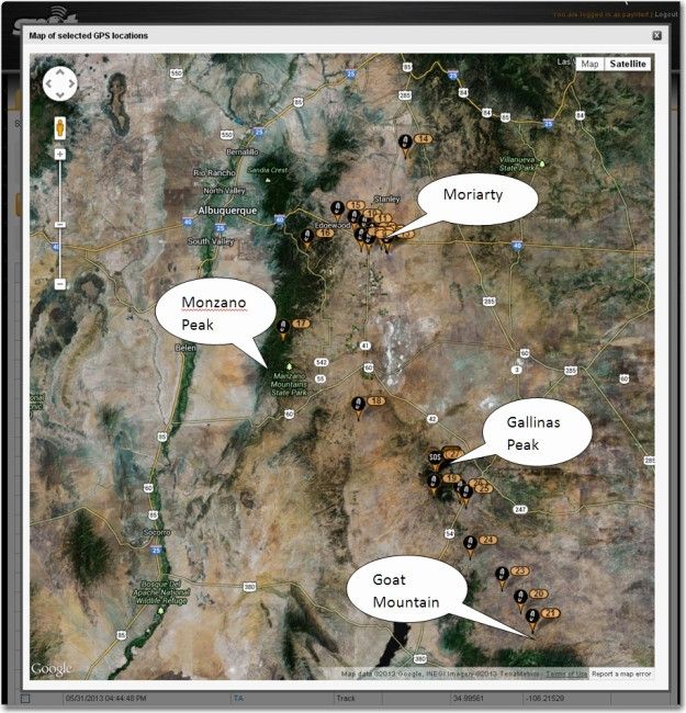
The task for the practice day was a 3-circle TAT. The first circle was to the north (Ortiz Mine), the second to the southwest (Monzano Peak) and the third to the southeast at Goat Mountain. A complicating factor was the white sands missile range restricted area, which forced pilots to either accept a significant deviation in the last circle, or to continue southeast to the center of the Goat Mountain circle.
Progress of the flight
This was a practice day, so there weren’t any points on the line. I viewed it as a good opportunity to work on blue day flying in an unfamiliar soaring area, but I was also determined to stay strictly within glide range of an airport at all times. I did NOT want to practice my off-field landing skills in unknown and apparently hazardous terrain.
The first and second turn areas (track positions 13-17) were accomplished without too much trouble, although the lift over the Monzano mountains wasn’t anywhere near as strong as I had expected. As I proceeded toward the 3rd circle (track positions 18-21), I noticed the winds had changed significantly, and the lift values and thermal tops were now considerably less than I had been getting earlier. I had final glide to an airport at the center of the third circle, and I had pretty much resigned myself to landing there. As I proceeded, I also noticed that the terrain I was flying over was not at all landable. I could most probably put the plane down and walk away from it, but I wouldn’t be flying again the next day (or week). Also, the wind direction had changed now to the southeast, which meant I was flying toward the lee side of a small mountain range situated just east of the center of the turn (and the airport I was aiming at). I was worried that my final glide margin over the airport might degrade as I got closer to the mountains, but when I arrived I was still well above my 1000’ agl minimum margin. I located the airstrip at Goat Mountain and tethered myself to it while looking around for lift.
I eventually found a 2-3kt thermal to 8500-9000’ msl (2500-3000’ agl), and was able to move on, as I now had final glide + 1000’ over the next airport to the north, back toward Moriarty. As I proceeded I continued to find weak climbs, but nothing that got me back up into the teens. I continued past two more airports (track positions 22-26), but when I arrived at the third airstrip at 14 Local, I couldn’t find the airstrip – yikes! I was about 1500’ agl at this point, so I wasn’t totally desperate, but the terrain below me was not at all inviting. There was a north-south 2-lane highway that I thought I might be able to land on, but there were almost certain to be obstacles within my 15-20 meter landing width. In addition, the road was carrying some traffic, maybe 1-2 cars every 4-5 miles or so. There wasn’t so much traffic that I couldn’t land at all, but it was definitely going to be ‘interesting’. There were a couple of other places that might work out, but nothing that wasn’t going to cause significant damage to the glider.
All of a sudden, the character of my flight had changed from a potentially long but otherwise uneventful retrieve, to serious and potentially dangerous situation, where I was going to have to make a landing soon, with only bad options to choose from. I was still looking for lift, but mostly focused on trying to work out how I was going to make this road landing work.
About then I ran into some lift, and starting working a thermal that started out at about 1kt, and slowly improved to 2-3kt. I was drifting downwind away from the road and into heavily treed higher ground, and the winds had picked up considerably. I was now faced with another unappetizing set of choices. I could stay in the climb as long as possible while drifting into even more unlandable terrain, or abandon the climb and run back upwind to a pretty much guaranteed damaging landing. I chose to stay with the thermal, reasoning that if I could take it high enough, I could make it back home or at least make it to another, hopefully more visible, airport or at least landable terrain.
The climb started at about 7000’ msl and continued to about 9000’ msl, where either it died or I lost it. At this point I had drifted well away from the road and any flat terrain, and I was well up into the treed foothills to the east of Gallinas Peak. The terrain downwind was mostly trees, although I could see some flatter open terrain to the north. I was about level with the crest of Gallinas Peak, so I decided to continue downwind and see if I could find lift on the upwind side of the mountain crest. The winds were now 17-20kt from the southeast, so I thought there was a good chance I could find a ridge-induced thermal, or at least decent ridge lift I could work.
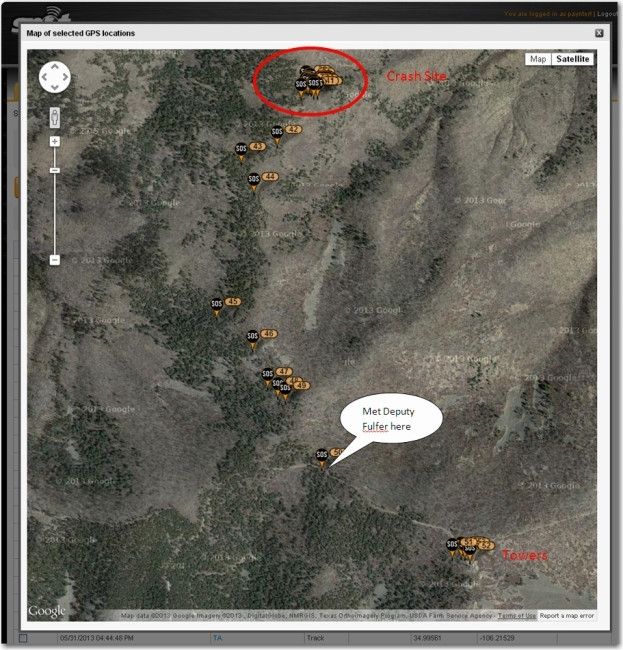
When I arrived at Gallinas Peak (track positions 27 – 30), I ran north along the ridge until I got to the north end of the ridge, where I encountered a very strong upward gust, which I thought might be my ticket home. I immediately pulled up and to the right (away from the mountain), and planned to S-turn (figure-8) my way up to the crest about 100-200’ above, and then try to climb away in the thermal. Unfortunately, as I completed the turn with my right wing parallel to the mountain, I discovered that I was being pushed right into the mountain, and almost immediately hit two very tall pine trees, and impacted the side of the mountain about 100’ below the crest on the east side. The glider came to rest pointing up the mountain at about a 30-40 degree slope, with the left wing in two pieces the fuselage in two pieces, and the right wing heavily damaged. The canopy was completely demolished, but the cockpit was miraculously not badly damaged. Other than a couple of scratches and a bruised right foot, I was completely uninjured. My soaring hat came to rest about 15’ from me in one direction, and I eventually found my secondary PNA (a brand-new Avier) about 15’ in the other direction, cracked and nonfunctional. My RAM-mounted ClearNav unit was now in my lap, with a huge hole in the back where the unit had ripped right off the RAM mount
Decisions
As I mentioned before, most aviation accidents are the culmination of a long ‘accident chain’ of decisions/actions, any one of which if done differently might have broken the chain and prevented the accident. So, what was the accident chain in my case? What were the decisions/actions that I made that if done differently would have produced a better outcome?
The decisions/actions that I can identify are:
- Flying the practice day task at all, given that it was a marginal blue day in an unfamiliar soaring area.
- Continuing the flight when conditions seemed to be getting softer.
- Continuing the flight over rough terrain toward an airport (#46 Lincoln Station) that I had not personally verified as being landable.
- Staying with a weak thermal even though it was drifting me away from (more) landable terrain.
- Attempting to ridge soar an unfamiliar peak in gusty conditions.
Of course it is natural for me to attempt to justify my decisions, but I really don’t know what I would change given the conditions and situation at the time. The decision that really put me in the hurt locker in the first place was the one to continue to the airport at Lincoln Station from #56 Monte Alto. I had previously moved from the airport at #40 Goat Mountain to Monte Alto and tethered myself there until I found another climb, and then moved on to Lincoln Station. However, this was just the continuation of my strategy for the day of always staying within good glide range (i.e. at least 1000’ above FG at MC 3.0) of an airport, as I did not want to try my luck at landing out in rough terrain.
When I replay this entire nightmare (or it replays itself in spite of my best efforts to not think about it), one of the things that strikes me is “what would I have done if I was able to locate the airstrip at Lincoln Station, and it was perfectly landable?” As it turned out, I found that thermal that got me back up from 7000’ msl to about 9000’ msl, pretty much right over the airport (or at least where the airport was supposed to be). So, would I have abandoned the thermal and landed, or continued on north into the high ground anyway? I would like to think that I would have stayed tethered to that airstrip until I definitely had a conservative glide to the next one to the north (68 Road, I think), and when I lost that thermal at 9000’ or so, I would have gone back to the airstrip.
I believe the real cause of this accident was my unwillingness to recognize that I was in a fundamentally different kind of environment than I was used to as an eastern flatland pilot. I have an absolute rule about never doing a dead glide to an airport that I have not personally inspected unless I sufficient altitude to get to the airport location at least 1000’ agl. This gives me time to find the airport if it isn’t exactly where the database says it is, and to pick an alternate landing field if the airport can’t be found. What I failed to appreciate about the Moriarty terrain (but is blindingly obvious in hindsight) is that I had been flying over really rough unlandable terrain for at least two hours, so the option of finding an ‘alternate landing field’ didn’t really exist. If that airport that I was gliding to wasn’t there, I was going to be in a world of hurt. If I had been able to consciously understand that I had lost an entire level of options, I may have decided earlier that I was in way over my head and either worked my way backwards over known airports or landed earlier. I simply continued in the mindset of a competition pilot on a race day, assuming that the worst that could happen to me was a more-or-less uneventful landout, even in the face of plentiful evidence to the contrary. Once that last airstrip failed to appear, the stage was set for the rest of the chain to play out.
The Rescue
In the following more less chronological account, I have included times to the best of my recollection. Some of the times are pretty accurate because they came from the logs of the 911 responders, particularly the IERCC (International Emergency Response Coordination Center) folks that handle 911 activations for SPOT. The initial SPOT 911 activation was logged at 0002 UTC, or about 6pm Moriarty local time.
After the dust settled, and I had gotten over the shock of discovering that I was basically uninjured, I immediately reached over to my right shoulder and pressed the 911 button on the SPOT. This was an automatic reaction, as I was still hoping that I was going to wake up at any moment from this nightmare in my Micro-Castle. My sunglasses went bye-bye in the crash (I later found one lens in the rest of the trash in my lap, but I never did find anything else of the glasses), but I was able to operate the SPOT because I had recently had clear-lens-exchange surgery performed on both eyes (another coincidental miracle) and no longer needed corrective lenses except for low-light-level reading.
The next thing I did was to climb out of the cockpit and stand beside what was left of my once-beautiful glider, and look out over the awe-inspiring terrain to the east. I could see forever, but I couldn’t see a single sign of human habitation – no roads, no houses, no nothing. I could just see the tops of some microwave towers a mile or two to my south, but nothing else. The wind was whipping up the slope at what felt like 15-20kt, and it was starting to get chilly. The thought occurred to me that it was going to be days before anyone could get up this mountain, and I was still in very serious trouble. I had miraculously survived the crash with very minor injuries, but I still might not survive the mountain.
I took off my parachute and laid it on what was left of my left wing, with the SPOT pointing up for best visibility to the satellite, and I reached back in to flip my ELT switch from ARM to ON (I didn’t know if the ELT had activated or not, but decided I didn’t care – switching to the ON mode couldn’t make anything worse, and might make it better.
Next I pulled my primary cellphone out of my pocket, and discovered to my amazement that I actually had decent service. I dialed 911 (thanks again to the CLE surgery last winter) and immediately heard something like “What is the nature of your emergency?” I told the 911 responder (Josh, last name unknown) that I had just crashed my glider at the 8000’ level on a mountain peak somewhere about 60 miles south of Moriarty. I knew I was south of Moriarty and east of the Monzanos, but that was about it. Josh had an approximate location from my cellphone signal, but I was pretty sure that wasn’t going to be of much help. I told Josh my navigation equipment had not survived the crash, so I couldn’t give him an accurate GPS position. I also told him that I had a SPOT device and I had already activated the 911 feature, so hopefully he would be hearing from the IERCC (International Emergency Response Coordination Center) soon. Josh wanted to know if I could see any obvious landmarks like road signs or towns, and I told him I couldn’t see anything but trees and desert forever to the east and north, and nothing but mountain to the west. It was at this point that I started to realize just how remote this site really was, and I told Josh that if he had access to air support, he might want to start the process of getting something into the air. At this point I tried to talk Josh through the process of bringing up my SPOT tracking map via the SSA Track a Sailplane List, but the effort failed when Josh reported that “the site was down” – VERY FRUSTRATING!! After about 5-10 minutes, I disconnected from Josh to conserve battery, and started thinking about how I could get a better GPS fix. I didn’t actually know if my SPOT ‘911’ feature was working, and I didn’t think that the cellphone location information available to Josh was going to help much, and might even significantly hinder the SAR operation.
I had several GPS-based nav systems in the glider, but they all appeared to be non-functional. The ClearNav had suffered major damage, with a huge hole in the back where the RAM mount and connector area had been ripped away. As far as I could tell, my Cambridge 302 was non-functional, and my Avier PNA was among the missing (I later found it 15-20’ from the cockpit, cracked and unusable). The SPOT was (hopefully) pumping out GPS positions, but I didn’t have access to them. Then I realized that if I switched the SPOT out of 911 mode and pressed the HELP button, the SPOT would send out my “Help, I have landed out and need a retrieve” message along with the GPS coordinates of the ‘landout’ – aha! I would receive a text message on my phone, and would have the coordinates to give to Josh in case the connection from IERCC to Josh didn’t get made for some reason (I was afraid the ‘local 911 responder’ from IERCC’s point of view might not be the same as the 911 responder I was talking to). So, I turned the SPOT off, then back on, and put it into HELP mode. I waited a few minutes, and then rather than look it up on my phone, I decided to call my wife who would also have gotten a HELP text message and email with the same GPS coordinates. I’m very glad I did, because she had already been contacted by IERCC, and she was understandably distraught. I was able to assure her that I was alive and well, although unsure how long I was going to be an involuntary mountainside camper/hiker. Because the IERCC folks had left her a contact number, I could now pass both the GPS coordinates and the IERCC contact number along to Josh, assuring (I hoped) proper coordination. I called Josh back and relayed this information, and then got started on how to survive the coming night.
It was now about 6:30pm, so I had at most a couple of hours of daylight left. That wasn’t much time to get a helicopter to me, and the wind had continued to pick up and was now pretty much howling up the mountain. This combination made me think that a helicopter rescue was probably not going to happen today, and that I probably could not hike out to civilization before dark. I hiked up to and over the mountain crest, considering my overnight camping options. The lee side of the crest was in the late afternoon sun, and out of the wind and so was warmer right now, but I didn’t see any obvious shelter. Also, I was concerned about wandering away from the crash site and getting lost in the dark, and/or having rescue personnel show up and not be able to find me. I considered setting up a lean-to and using my parachute as a wind break, but didn’t want to try that unless I couldn’t figure out something better. I hiked up and over the crest and back to the crash site, where I suddenly realized that I might be able to camp out in what remained of the cockpit. It was actually relatively intact, and some experimentation revealed that my normal reclined flying position protected me almost completely from the wind. Although the glider was on a pretty good slope, it didn’t look like there was any danger of it starting to slide, but I could always use my tow-out rope to secure the nose to a nearby tree. I had my heavy-duty canopy cover and my parachute for warmth, so this was starting to look like the best option to survive the night. I didn’t have a flashlight or matches or anything like that, but as long as I got everything done by dark I should be OK. So, I had a plan to survive the night, and hopefully I would be rescued the next day, either by helicopter or by a rescue team hiking in.
Now that I had a plan, I took a few minutes to take stock; I was basically uninjured, in good health, and was in no immediate danger. I had been operating on pure adrenaline for at least an hour before the crash, and for the 30-45 minutes that had since lapsed afterwards. I had done pretty much everything I could think of to move the rescue operation forward, so now I just had to wait it out until help arrived. I looked out over the valley, and was again amazed at how remote and inhospitable the whole area seemed. I felt like I had stepped through a looking-glass somehow, going from high-tech flying machine to pre-historic times in the blink of an eye. Somewhere along in here, Mark Hawkins called – he had seen the HELP message (he had been watching my SPOT track on his PC back at Moriarty), and was wondering how in the heck he was going to get a trailer into where I had landed/crashed. I explained to him that the trailer wasn’t going to be necessary, unless he had a way of airlifting it in. Mark was mortified that he had encouraged me to come out and fly in Moriarty, and now I had crashed my airplane. I told him I was most probably not getting off the mountain until tomorrow at the earliest, and asked him to call my wife and keep her updated on the rescue effort .
It was now about 7pm, an hour after the crash, and about 1 hour before sunset. I had just started making final preparations to cocoon myself in my cockpit for the night when I got a call from Grady (last name unknown), who identified himself as the rescue coordinator from the New Mexico Search and Rescue Council (NMSARC). This group has a lot of experience with rescuing lost/injured hikers/skiers, and were very familiar with remote location rescue efforts. Grady had received the GPS coordinates supplied by the IERCC folks, and had plotted them on an accurate topo map of the area. He was able to tell me that there was a service road to the microwave towers I could see in the distance, and if I was able to hike about 1 mile due south, I should be able to intercept the road and rendezvous with a sheriff’s deputy currently heading in that direction. This was GREAT news – I might not have to spend the night up here after all! I looked to the south and compared what I was seeing to what Grady was telling me; I could see that I would have to traverse a saddle in the ridge line and work my way up and over a higher peak to the south to get to the road, but it looked doable. Grady and I compared notes, and he agreed that the terrain features he was seeing on the topo map matched what I could see from where I was. I told Grady I would make some preparations and call him back when I was ready to set out.
By 7:13pm I was ready to go. I pulled my landout kit out of the glider, and stuffed my canopy cover and my small waterproof rug into it. I strapped my CamelBak onto the back of my parachute, which I then strapped back on. My lunch bag with my remaining food and an almost-full Gatorade bottle got strapped onto the front of the parachute where I could reach it easily on the hike, and my landout bag went over my shoulder. I knew that the greatest danger I faced now was getting injured or lost on the hike south, and I was determined to take whatever I needed to survive a night in the open. My SPOT was still strapped to the parachute, and I had put it back in 911 mode, so at least the eventual rescue party would be able to find my body if I didn’t make it out.
Before I left I looked around for a few moments, as I was pretty sure I wasn’t ever coming back here one way or another. I thought to turn off the O2 bottle valve, and I tried but failed to remove the O2 regulator and EDS pulse-ox system, as it was a loaner from a friend and I didn’t want to leave it behind. I gave up when I realized I was wasting valuable sunlight time, and it would be ironic to be killed by a balky EDS system at this point. I didn’t realize until much later that I hadn’t thought to turn the ELT off (rats!) or take any cellphone photos of the crash site (double rats!), but those items were pretty far down my must-do list at the time.
I called Grady, told him that I was starting out, and made arrangements for him to call me in an hour at 8:13pm for an update on my status, in case I got injured or lost during the trip out. Then I set off at an easy pace, with a handy tree limb fashioned into a walking stick.
The first part of the hike was downhill and easy, as I traversed the first part of the saddle. A forest fire had gone through the area about 5 years ago, so there were a lot of downed trees to negotiate, and a lot of brush, but nothing really too hard. However, once I started back up the other side of the saddle, things got a little more interesting. I was in pretty good shape overall, but hiking up a steep mountainside at 8000’ msl was definitely outside my comfort range. I kept going (what other choice did I have?), but tried to be very conservative about how hard I pushed and what route I took. There were a few game paths, but mostly I just zig-zagged back and forth a few hundred yards at a time. Every 15-20 minutes I stopped for a few minutes and took a break and a drink, but I knew I was fast running out of daylight.
When I started the hike, I almost immediately lost sight of the microwave towers that were supposed to be the terminus of the service road. As I progressed south, I began to wonder whether I was still going in the right direction, or had I somehow managed to get off on the wrong ridge. I knew the microwave towers were at the highest point of Gallinas Peak at about the 9000’ level, and I knew I was heading toward that peak, but it still bothered me that I still couldn’t see anything like a tower through the trees. I resolved that I would continue as planned, and If I didn’t find the towers or the road by the time I reached the highest peak, then I would camp there for the night. All this time I wasn’t really thinking about anything but the next step, then the next place to turn back for the next part of the zigzag route, and the best route up the mountain. I felt I had to concentrate solely on this one task if I wanted to get out of this mess safely (track positions 13-17).
At 8:13pm I hadn’t heard from Grady, so I stopped to give him a call. Just as I was getting ready to stop, I realized two very important things. I could now see the microwave towers again, and I could see what I later confirmed to be the service road up to the towers. It was starting to get dark, but I could see that I was going to make it to the road before I ran out of daylight. Before I called Grady I considered my options; I was now sure I could make it to the road, but I wasn’t sure what to do after that. I could continue up to the microwave towers, hoping to find some shelter where I could wait for the sheriff’s deputy, or I could start down the mountain, hoping to meet the deputy’s car on the way. I didn’t like either choice, but my dislike of a further uphill trek was overridden by the image of getting run over in the dark by the very person sent to rescue me, so I resolved to go on up to the towers. I called Grady to tell him this, but got voice mail instead. I left the message that I had the road in sight, and that my plan was to continue along the road up to the towers.
By 8:15pm or so, I reached the service road, and was never so glad in my life to see some sign of civilization. I was actually quite impressed with the road – it was just a dirt road, but it looked like it had been well maintained, and I could see where some fallen trees had been recently cleared away. Just as I sat down on a cut tree stump to take a break, I heard a curious rhythmic thumping sound, kind of like a tracked vehicle of some sort. I looked down the mountain and saw a pair of headlights coming, and soon saw that it was a 4-wheel drive pickup truck, presumably the deputy. As he approached, I grinned and put out my thumb – feeling a little giddy that maybe this was all going to end well after all. Out of the truck comes a very large deputy sheriff, one Ron Fulfer, who fortunately saw the humor in a hitchhiking glider pilot on the side of a mountain road in the middle of nowhere. He asked to see my driver’s license and after verifying that I was indeed the guy he was looking for, called in to his dispatcher with the news that he was with the pilot and I appeared uninjured.
Crash Site
As it turned out, the day’s adventures weren’t over quite yet. The ‘tracked vehicle’ noise I had heard as the truck rolled up was due to the fact that the sheriff was running on a flat tire – and he didn’t have a jack. He had continued up the mountain on the flat, but there was no way we were getting back down again without swapping out the tire. After talking about it for a few minutes, we decided to continue up to the towers, figuring we could turn around there and wait for a wrecker, and maybe there would be someone up there with a jack. On the way up to the towers, I called my wife and told her I was OK and with the deputy, so everything was going to work out. Then I called Mark and told him the deputy had offered to take me all the way back to Moriarty, and he agreed to wait there for me.
When we got to the top, we found there was indeed someone there, and they did have a jack. Turns out one of the structures there is a fire tower, and it was ‘manned’ by a lady forest ranger. She told me she had actually seen me go by below the tower on my way north, and was very concerned when she didn’t see me come back south. She almost (but apparently didn’t) call 911 herself. In any case, she had also experienced a number of flat tires on the service road, and carried *two* spares and a hydraulic jack – yay!
Deputy Fulfer called off the wrecker, and the two of us set to work on swapping out the flat. It wasn’t the easiest tire job I’ve ever done – it was on uneven ground, at night, on top of a 9000’ mountain, but on the other hand I was highly motivated to get it finished so I could get the heck out of there. Within half an hour or so, we had thanked the ranger and were heading back down the road. It took a loonnnng time to get down off the mountain, and we drove at least 20 miles through god-awful terrain before we hit the first paved road. On the way we passed numerous splits and side roads; I realized that if I had decided to go downhill instead of uphill when I got to the road, I might still be out there wandering roads to nowhere – yikes!
About 2 hours later (I’m guessing around 11pm) we rolled up to my truck at Moriarty airport. Mark was waiting for me in his truck, and after thanking deputy Fulfer profusely, Mark and I repaired to the Micro Castle for a beer. We talked for about an hour, and then Mark went home to bed and I took a shower and tried to get some sleep. At about 3:30 am I gave up on sleep, and decided instead to start back home. There was absolutely no reason for me to stick around at Moriarty, and I was 1500 miles from home and a very distraught wife. By 4:30 I had loaded the camper up on the truck and was on my way home.
Timeline Summary
This is the timeline as well as I can reconstruct it – all times are local
1700: Arrived over Lincoln Roads airstrip, but couldn’t find it.
1800: Crashed onto the eastern slope of Gallinas Peak, at the 8000’ level.
1802: IERCC receives first SPOT 911 activation. The duty officer at the time was Delray Bruce, and he immediately reached my wife Jo Anne at the primary emergency contact number. She was able to tell them that in all probability the 911 activation was a real emergency. Delray told Jo Anne that they would immediately start rescue procedures, starting with alerting the local 911 responder. IERCC’s policy is to start with the sheriff’s office for the county in which the activation occurs, as there is a sheriff’s office for every county in the USA (In Canada, the first contact is with the RCMP). Delray left his contact information with Jo Anne, and promised to keep her in the loop with regular updates.
1801/2: I call 911 and get Josh in the Torrance county 911 dispatch office.
1803: I switch my SPOT from 911 to HELP mode so I will (hopefully) get a text message containing the correct GPS position info
1807: I call Jo Anne to tell her that I’m OK, and find out that IERCC has already contacted her, and has the correct GPS location
1810: Josh, the Torrance county 911 responder, is contacted by IERCC with the GPS coordinates from my SPOT.
1812: I call Josh with the same information, and am told he is already in contact with IERCC (at this point I’m still a bit confused, because up to now I knew the IERCC folks as ‘GEOS’. Turns out that GEOS is the company name and IERCC is the functional entity).
1900: I get a call from Grady of the NMSARC, with the information that there is a road 1 mile due south. If I can get there, they can arrange for a sheriff’s deputy to pick me up on the road.
1913: I start walking
2013: I can see the towers and the road
2030: I am at the road and am almost immediately met by the sheriff’s deputy
2100: IERCC notified that I was with the deputy, and they could stand down
2130?: Flat tire fixed, headed down the mountain
2300?: Arrive back at Moriarty.
Lessons Learned
- Arguably, this entire story could have been avoided if I had consciously understood and acknowledged a basic fact about at least this section of the Moriarty soaring area – except for airports the entire area is basically unlandable, at least as far as I could determine. I couldn’t really see any area that wasn’t covered with sagebrush, scrub trees, or obviously rolling terrain, cut up with arroyos or other impediments to landing. A landing in any of these areas was most probably going to result in significant damage to the glider. This by and of itself wasn’t unmanageable, as I had planned all along to stay within easy glide range of an airport, and did so for the entire duration of the flight. What I failed to consciously take into account was what was going to happen if Plan A (get high, stay high, go fast) didn’t work and the Plan B airport failed to materialize. If I had really thought consciously about this, I would hopefully have realized that I was in over my head and the best thing to do was to either get high enough to get all the way home in one shot (or at least to get into the more landable terrain nearer Moriarty), or to land where I knew I had a viable airport and accept a longer (but otherwise uneventful) retrieve.
- There were some things missing from my landout kit that I plan to have in there the next time I go flying. I didn’t have a flashlight of any sort, and I didn’t have any means of making noise if necessary (i.e. a whistle). I don’t like flashlights in landout kits because the batteries are invariably dead when you need them, but it sure would have been nice to have had one when I was contemplating an overnight stay in the mountains – so maybe a wind-up flashlight of some sort. A whistle could have come in real handy to assist a rescue team in finding me if I had been incapacitated. Also, I didn’t have a spare pair of reading glasses in there, and that could have been a major problem. Fortunately my eye surgery last winter gave me good enough near vision to get by on, but I still plan to put a pair of cheaters into my kit.
- The landout kit I did have functioned pretty well; I had rope, food, water, covering material (canopy cover, waterproof rug, parachute), two different cellphones (both of which had coverage in this particular case), and a bag with a long enough strap so I could put it over my shoulder.
- I have seen lots of pilots flying in shorts, T-shirts, and somewhat flimsy shoes, and I have always refused to do that. I always wear good jeans, a long-sleeved fishing shirt and a good pair of running/training shoes. I don’t really want to think about having to make the hike I did without good shoes, and/or spending the night out on the mountain in shorts and a T-shirt.
- If you need glasses to see or read, make sure you have a spare pair tucked away where they will survive a crash. The ones you are wearing will be destroyed in the crash! I did eventually find one lens of my ‘reader’ sunglasses, but I never found the frame or the other lens.
- If you are a cross-country pilot and don’t have a SPOT or Delorme InReach unit – get one, and put its URL on the SSA Sailplane Locater List. Although in this particular case I might have been able to walk out of the crash site without the help of accurate GPS positioning info, it was much more likely that I would have been incapacitated to some degree, making a self-rescue impossible. In that much more probable scenario, my SPOT would have literally saved my life.
- The SSA Sailplane Locator List, a potentially life-saving feature on the SSA website has become too hard to use for its original purpose – locating downed pilots in remote areas. The link to the list is now buried under the ‘Member Resources’ menu, and the ‘Track a Sailplane’ magnifying glass icon that used to link directly to the locator list has been hijacked by the new ‘Live Tracker’ application (Figure 3). When Mark Hawkins, Doug Easton, I and several others created the Sailplane Locator List years ago, we specifically made sure that the magnifying glass icon would be prominently displayed so that 911 responders or other law enforcement personnel could be directed there easily by anyone concerned about a missing pilot. We made sure it was easily visible and accessible whether or not you were an SSA member, just for the type of situation I found myself in (and this was the subject of some heated discussions at the time). When I tried to direct Josh to the locator list, I told him to look around on the home page for the magnifying glass icon because I wasn’t aware that it had been hijacked by the live tracking feature. When he clicked on the link (and then the stupid ‘Accept’ button), he got the error message shown in Figure 4 below BECAUSE THE LIVE TRACKER APPLICATION DOESN’T WORK WITH INTERNET EXPLORER – THE BROWSER THAT MOST EMERGENCY SERVICES DISPATCHERS STILL USE!!!! . If I had been incapacitated and unable to activate the SPOT 911 mode, it is quite likely that someone (maybe Mark Hawkins or my wife) would have tried to get the local 911 responder to access the Sailplane Locator list to provide them with SPOT tracking information and it most likely would not have worked, denying the rescuers critical position information. Of course, the locator list link IS available under the ‘Member Resources’ menu, but IMHO it was somewhat short-sighted to re-purpose a well-thought-out and useful safety feature (the magnifying glass icon and the underlying locator list) with what is essentially marketing eye-candy that has nothing to do with safety. It was more than a little bit ironic that I, as one of the original creators of the Sailplane Locator List, wasn’t able to get the 911 responders connected to it during my emergency.
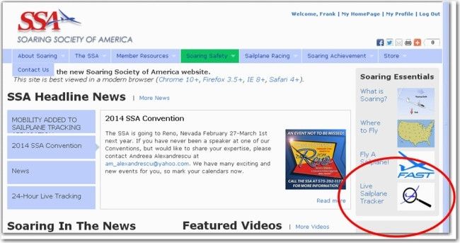
Figure 3: Can you find the Sailplane Locator List on this page? Hint – it isn’t the circled icon anymore!
Conclusion
As I said at the beginning of this account, most serious accidents are the result of a chain of events or decisions. Changing any one of these links could break the chain and prevent the accident. Some of the links are known to or controllable by the pilot, and some aren’t. In my case, I think the links were the following:
- Less than stellar practice day weather. If this had been an 18,000 day with cloud streets forever, the accident probably would not have occurred.
- An unanticipated change in wind/weather conditions late in the day. The day started out with light & variable winds as forecast, but later in the day the winds picked up to 17-20kt out of the southeast, with a concomitant degradation in the B/S ratio.
- Rougher terrain than expected – at least for me. The terrain around Moriarty seemed to be much more landable than the area to the south where I wound up, and as a newcomer I wasn’t aware of that. I assumed that landout opportunities might not be particularly convenient, but there would at least be some!
- A missing airport at Lincoln Road. It may be there, but I couldn’t find it and I was looking pretty hard for a pretty long time.
- Pilot unfamiliarity with the area, and a ‘flatland mindset’ regarding Plan C – find an acceptable alternative landing field if Plan A (stay high and go fast) and Plan B (land at an airport) don’t pan out.
If any one of factors 1-4 had been taken out of the chain, the accident would probably not have occurred. Given that all four were present at the same time, then the 5th link noted above was the only thing standing between me and a mountain. I wasn’t smart enough to figure that out ‘on the fly’ and take corrective action or land safely while I still had the opportunity to do so.
As a postscript to this account, I would like to thank all the people who called and wrote and emailed to tell me that it was OK to survive, and that they hoped I would be back soaring soon – I was truly an emotional basket case and such widespread expressions of support (I even got one from a Swedish national pilot I met through Condor) helped A LOT! I especially want to thank Mark Hawkins (OS), who besides being a long-time friend and business associate, was right there waiting when deputy Fulfer finally delivered me to the Moriarty airport. He stayed with me that night until he was sure I was OK, and offered to stay the night in the Micro Castle if necessary. Since then he has tirelessly handled all the problems I left in my wake at Moriarty, including unpaid bills and an orphan trailer. Thanks Mark – I owe you big time.
Frank Paynter (ex-and-possibly-future TA)
 Aviation Safety Culture includes discussion of your own experiences and errors which everyone can learn from. Have you experienced or witnessed incidents which could be interesting for our readers? Aviation Safety Culture includes discussion of your own experiences and errors which everyone can learn from. Have you experienced or witnessed incidents which could be interesting for our readers?
Share your experiences with others! Flight safety in gliding can only be improved when incidents are worked through and the findings distributed. Write to: helge@soaringcafe.com, we will publish any suitable letters received. Please let us know if you prefer to not have your name or other identifying information to be disclosed. |

29 comments for “The End of The Road for TA – Part II, the Crash Report”